
Suðureyri is a fishing village on Súgandafjörður, reached through a tunnel under the mountain. This guide covers the essentials for your visit: how to get here, how to drive through the tunnel safely, and where to check the weather and road conditions. More chapters will be added over time.
Take the guide out of range
Save the guide in English to your device. It works without a signal.
The download covers: the cover page, 2 chapters, 10 photographs and both maps.
About 1190 KB in total.
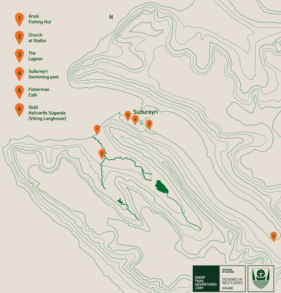
- Ársól Fishing HutRebuilt; about 30 minutes on foot from the village.
- Church at StaðurOutside the village, by the farm at Staður.
- The LagoonOn the edge of the village.
- Suðureyri Swimming poolA geothermal pool.
- Fisherman Café
- Skáli Hallvarðs Súganda (Viking Longhouse)A reconstruction of the house of the fjord's first settler.
Suðureyri lies on Súgandafjörður. Farther into the fjord are the farms of Staður and Bær, as well as Botn, which comes into view almost as soon as you leave the tunnel.
Before the Vestfjarðagöng tunnel opened in 1996, Suðureyri was reached by a coastal road or over a mountain pass. In winter, the journey could become impossible. Today the drive from Ísafjörður takes less than half an hour in good conditions, and the tunnel provides access throughout the year.
Fishing remains central to village life. You can see it in the wooden hjallar where fish dries through the winter, the boats in the harbour and the processing plants by the quay. Summer also brings visitors for fishing trips, the geothermal pool and the August festival Act Alone. The festival began in 2004 and has been held in Suðureyri since 2012.
In 1974 Auður Eir Vilhjálmsdóttir took up her first parish here, the first woman ordained to the priesthood in Iceland. Before she could be ordained she had to find a congregation willing to call her, and she found one in Suðureyri. Hans Kristjánsson, the founder of 66°North, also came from Suðureyri. The local heritage society, Fornminjafélag Súgandafjarðar, has rebuilt Ársól, a seasonal fisherman's hut, and Skáli Hallvarðs Súganda, a reconstruction of the home of the fjord's first settler.
The village sits in a natural hollow surrounded by steep ridges. Most of the nearby trails are unmarked. That is one reason this guide exists.
Contents
This page is part of a project supported by Uppbyggingarsjóður Vestfjarða.
Spotted something wrong, or have something to add? Write to us.
Last updated: . Weather and road conditions can change quickly. Always check the latest information at the source before you set out. New chapters will appear in the contents above.
Back to the main page