
The fjord before the village
Suðureyri is a little over a hundred years old. The fjord it stands on has been lived in for a thousand. That difference explains almost everything: why the village sits on the flat strip by the mouth, why its coat of arms carries three fish, and why the oldest things you will see here have been rebuilt rather than preserved.
People lived around Súgandafjörður long before Suðureyri existed. A register of farms from 1858 lists fourteen of them in Suðureyrarhreppur: Staður in Súgandafjörður together with Staðarhús, Vatnadalur fremri and Vatnadalur neðri, Bær, Suðureyri, Laugar, Kvíarnes, Botn and Klúka, Gilsbrekka, Selárdalur, Norðureyri, Göltur and Keflavík.
Most of those names are still on the map, although some of the places now stand empty. Driving in from the tunnel you pass Botn. Staður and Bær lie in the valley behind the village, and Norðureyri and Göltur are across the water. The list is the shortest possible description of what the fjord was for a thousand years: a landscape of farms, not a settlement.
The name Suðureyri itself appears in documents as early as 1471, in a transfer of land. Then, and for another four hundred years, it meant a single farm rather than a village.
Hallvarður súgandi, and what the sources do not say
Hallvarður súgandi appears in two medieval sources. Chapter 50 of Landnámabók records that he fought against King Haraldur at Hafrsfjörður, came to Iceland, took Súgandafjörður and Skálavík as far as Stigar, and settled there. The opening chapters of Grettis saga name him among the companions of Önundur, Bálki and Ormur.
His byname, súgandi, is connected with wind, current and swell. The fjord carries the same name.
These are important accounts, but they are not reports written down at the time of the settlement. The surviving versions of Landnámabók were composed several centuries later and were edited around the turn of the thirteenth and fourteenth centuries. The honest way to put it is that according to Landnámabók Hallvarður was a settler in Súgandafjörður. Not every detail of the story is confirmed by archaeology.
Botn as the site of his farm calls for even more care. The place name archive of the Árni Magnússon Institute records a local tradition that Hallvarður lived here, and notes in the same breath that this is too weak a basis for a firm conclusion.
Skáli Hallvarðs Súganda
A modern reconstruction of a settlement-age longhouse stands at Botn. No farm of Hallvarður's has been found here, and the building does not recreate one that stood on this spot. The name commemorates the person, not a discovery, and it is worth knowing that before you walk out there.
The model is archaeological. The building follows Grélutóftir, a site at the mouth of the Hrafnseyrará in Arnarfjörður, where Þjóðminjasafn Íslands excavated in 1977 and 1978 under Guðmundur Ólafsson. The dig uncovered a small skáli with an annexe, two sunken buildings and traces of ironworking. The skáli itself was 14 metres long and 5 metres wide. On that basis the Argos practice designed a tilgátuhús, an interpretive reconstruction, with Guðmundur Ólafsson as consultant.
Fornminjafélag Súgandafjarðar, the local heritage society, began building in the summer of 2019 and worked in stages: first the turf and stone walls, then the timber frame and roof, and finally the interior with its langeldur, the long hearth. The turf comes from Botnsdalur, the timber from Tunguskógur near Ísafjörður and from driftwood at Hraun on Skagi.
From the start the way of working mattered as much as the result. In August 2019 Kristín Auður Kelddal Elíasdóttir ran a workshop on cutting and laying turf and on building with stone. At the next stage Valdimar Elíasson taught the timber frame and the roof, and Sighvatur Dýri helped to find suitable wood.
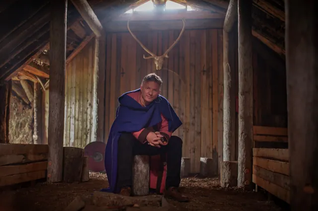
The house opened to the public on 10 August 2024, during the Westfjords heritage day. Eyþór Eðvarðsson spoke about Hallvarður and about how the house was built, and the programme also included talks by archaeologists and stories about heritage sites in the Westfjords.
The house is not a staffed museum. Much of the time it stands quiet and empty, and now and then it holds a concert of old Icelandic music.
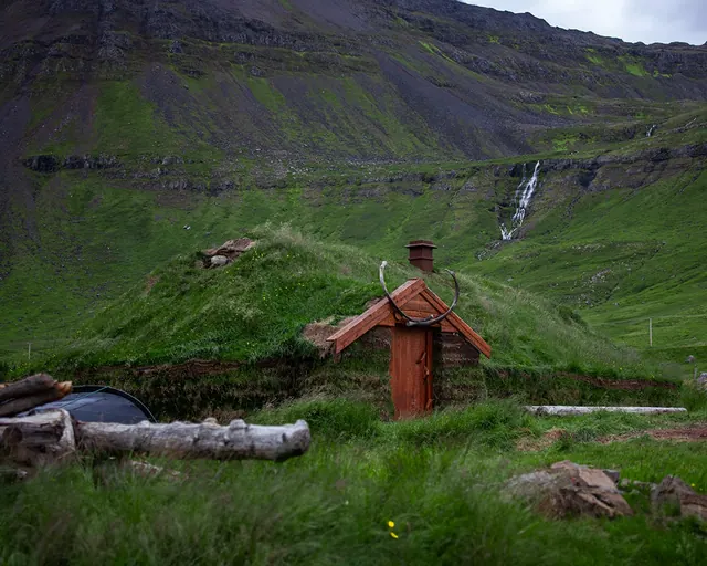
The rules for visitors came from something specific: in September 2024 someone lit a fire beside the skáli. They are simple, and worth knowing before you set out.
Before you go in
Leave the place as you found it. Take nothing away and leave nothing behind. Do not light a fire. Check the signs on site as well, because they may be newer than this guide.
How the village came to be
Suðureyri is young. For centuries it was one of the farms around the fjord, while Suðureyrarmalir, the flat strip above the shore, served as the main fishing station of Súgandafjörður. Only at the end of the nineteenth century did anyone settle there for good.
- 1889the first permanent residents settle on Suðureyrarmalir
- 1892a new assembly house, a þinghús, is built on Suðureyrarmalir
- 1899Suðureyri becomes an authorised trading place, a löggiltur verslunarstaður
- around 1900the village proper begins to take shape
- 1926local women set up a fund to build a church
- 1937the church is consecrated on 1 August; Jón Jónsson, a carpenter from Flateyri, designed and built it; 160 seats
- 1974the parish calls Auður Eir Vilhjálmsdóttir
- 1 June 1996Suðureyrarhreppur merges with five other municipalities to form Ísafjarðarbær
- 1996the Vestfjarðagöng tunnel opens and ends the village's isolation
- 1998, 2000 and 2002stained glass by Benedikt Gunnarsson is installed in the church
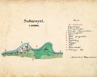
The oldest plan of the village we have been able to find dates from 1913 and is drawn at 1:10 000, with hand-coloured buildings and a numbered key. Súgandi, the magazine that published it in 2014, called it the first map of Suðureyri. It came to light during a search for old maps at the library in Ísafjörður, inside an article about the founding of the local heritage society. It is worth comparing with what you see from the road today: the strip by the shore is the same, and there are more houses on it.
The rest of the story is told by the number of residents. The figures come from Hagstofa Íslands and are drawn from two tables with different reference dates, so the join between them should not be read as a change from one year to the next.
Up to 1990 the figures come from one Hagstofa table, from 1998 from another with a different reference date; the dashed segment is the seam between them.
Population of Suðureyri, Hagstofa Íslands.
All the figures
| year | population |
|---|---|
| 1910 | 174 |
| 1920 | 315 |
| 1930 | 343 |
| 1940 | 362 |
| 1950 | 349 |
| 1960 | 379 |
| 1970 | 459 |
| 1978 | 526 |
| 1980 | 500 |
| 1990 | 365 |
| 1998 | 259 |
| 2002 | 321 |
| 2010 | 299 |
| 2017 | 251 |
| 2020 | 270 |
| 2024 | 296 |
| 2025 | 293 |
| 2026 | 301 |
From a little over a hundred and seventy people in 1910 to 526 in 1978, at the height of the era of trawlers and processing plants, and then a fall of almost half. Since 2000 the village has stayed between 251 and 321 people. On 1 January 2026 there were 301, the highest figure since 2002.
This is the history a photograph cannot show: a village that grew threefold once and halved once, and did not disappear.
Three fish above a wave

The former municipality had its own coat of arms: three stylised fish with the sea below them, all in blue. The council of Suðureyrarhreppur adopted it in 1984. Matthías Ástþórsson prepared the original proposal, and Viðar Aðalsteinsson, the municipal manager, gave it its final form.
The emblem exists in two versions, and that is no accident. In the press notice announcing its adoption, the fish face the opposite way from the register and from every later use. One printing error is the reason both variants are still in circulation.
After the municipalities merged in 1996 the Suðureyri arms stopped being an administrative symbol and became one of the four quarters in the arms of Ísafjarðarbær. It did not leave the street, though: the local rescue team asked for permission to use it in their own badge, and a casting with the three fish still sits on street furniture in the village. It is worth looking for.
Ársól and the seasonal fishing huts
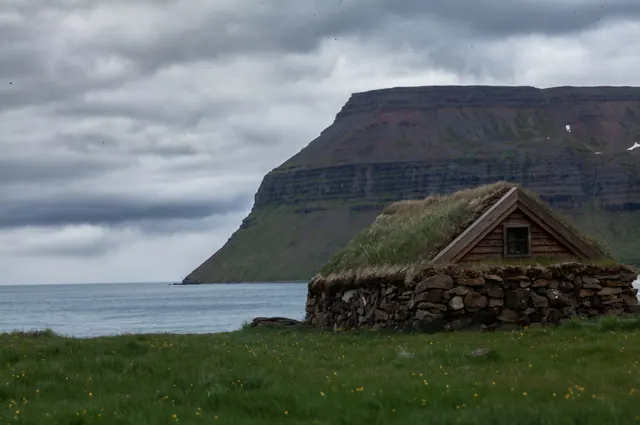
Before the fishermen had boats with engines and a harbour, they had verbúðir: seasonal huts by the shore where they lived for the length of the season. They were built from what was at hand, which meant stone and turf. The walls were laid in courses of stone packed with smaller stones and earth, the roof was turf over a timber frame, and the floor was left as bare earth. Building one took several weeks, and the roof needed constant repair, because the wind tore the turf away.
Life in such a hut was more strictly organised than its appearance suggests. Every verbúð had someone appointed to look after the oil lamps, and the formaður, the skipper, chose his sleeping place first. The food was mainly dried fish, cod liver oil and rye bread.
Ársól is a reconstruction of one of these huts and stands right on the shore, west of the village. Valdimar Össurarson designed it, following old huts at Kollsvík, and Eyþór Eðvarðsson led the building as part of the work of Fornminjafélag Súgandafjarðar. It was completed in 2021. Inside there are stone bunks and space for tools, and the cooking was done outside. Compared with the larger verbúðir at Bolungarvík, Ársól is deliberately minimal, and that is its point: this is what conditions were like on a small fjord.
Getting there
It is about half an hour on foot from Suðureyri, along a road cut into the hillside. In early spring watch for falling rocks: walk without headphones and keep to the seaward side. It is safer in summer, but rocks still come down. You can also drive. On the right there is a beach that looks different every day: sand one time, nothing but boulders the next.
Traces of the old fishery
Fishing here is not only history. It is what you can see from the road.
The oldest trace is the hjallar, the wooden racks where fish is dried in winter in the sharp, salt air. It is the same method that fed the fjord before there were cold stores, and it still works without electricity.
Boats lie along the quay and the processing plants work right beside them. The fishing is mostly done by línubátar, small boats using longlines, and seasonally with handlines. The method keeps bycatch low and lets the crew release what is not needed. Catches fall under the Icelandic system of individual quotas, so how much each boat may land is set in advance.
What comes up most often is cod (þorskur), wolffish (steinbítur), haddock (ýsa), redfish (karfi), plaice (skarkoli) and saithe (ufsi).
Half an hour on foot and a hundred years separate Ársól from the harbour. It is probably the shortest way to see how far this village has come.
People, memory and what is still alive
The first woman ordained in Iceland had her first parish here. Auður Eir Vilhjálmsdóttir was ordained on 29 September 1974 and took up the post at Suðureyri on 1 October. The order matters: this congregation called her when others would not, and only that opened the way to ordination.
66°North began here. Hans Kristjánsson founded the company at Suðureyri in 1926 under the name Sjóklæðagerð Íslands, making oilskins for fishermen and labourers. In the early 1930s the business moved to Reykjavík, and the name 66°North was adopted in 1977, after the latitude of the Arctic Circle.
Memory here has its own organisation. Fornminjafélag Súgandafjarðar was founded in the autumn of 2013, with its founding meeting held in the cooperative building in Suðureyri. The society works in several groups: one records heritage sites, another records the accounts of the oldest residents, and a third works on place names.
That last one deserves a sentence of its own. There are thousands of known place names in Súgandafjörður, and only a small part of them have been recorded. The group is led by Birkir Friðbertsson, a farmer, and the names go into the database of Landmælingar Íslands, the national mapping agency. It is work you cannot see from the road, and without it half of this guide could not have been written.
The same society built Ársól and the skáli, and it was their work in the archives that brought the 1913 plan of the village shown above back to light.
Part of this history is still happening. In September there is the smölun, the round-up that brings the sheep down from the mountains, and it ends with soup shared by everyone who took part. In June the village keeps Sjómannadagurinn, the seamen's day. In August the community hall hosts Act Alone, a festival of solo performance founded in 2004 by the actor Elfar Logi Hannesson. Suðureyri has been the host since the ninth edition, that is since 2012. Admission to everything has been free from the very first festival.
Nature and the seasons · in preparation
Contents